Judbarra (Gregory) National Park – “One of the Most Prolific Sites in Australia”

The second day adventure were combination of two states activity within the whole day. In the morning, we traveled around 3 hours from Katherine to Judbarra or Gregory National Park where we did a trek. The group followed the 1.7 km loop of Nawilbinbin Walk as our last adventure activity within Northern Territory. Then, later afternoon we crossed the border to Western Australia to reach the first place of adventure which was cruising and swimming in huge man-made lake called Lake Argyle.

I woke up early in the morning so I can still pack again some of my stuff back to my luggage while inside my permanent tent. Then, I checked if I can do something to help for breakfast with the group. Some had boiled the water, some prepared bread spread, some took off the fresh milk for the cereals. Everyone has something to do. After the breakfast, we took care as well the cleaning of the mess we made and returned everything back to the truck.

After everything were finished, everyone returned to our tents to put all our stuff back to the truck. We arranged everything at the compartments at the back of the truck where all the group’s luggage, tables, chairs, gas tanks, fresh goods, groceries, seasonings for cooking and others stuff that we used every time we eat in middle of remote wilderness for the group’s survival. When the group was ready, we left the tent village to continue the second day adventure. My excitement spikes again as I was wondering what kind of adventure we were going to do for the day and what kind of place we were going to discover and experience.

IMG_7813_s

This slideshow requires JavaScript.

Victoria River

From Katherine, we drove along Victoria Highway towards Gregory or now called as Judbarra National Park. We stopped for few minutes in Victoria River Crossing where we had a chance to see the famous river itself which became so important in the region. Then we returned to our truck and drove straight to our destination. From sealed road of national highway, we drove a bit to unsealed road which called Joe Creek which still good for 2WD vehicle. Then, the group got off from our truck and we had at least 2 hours of trekking following the Nawilbinbin Walking Trail.

IMG_7631_s

IMG_7561_s

IMG_7562_s

Along Joe Creek to Parking Area

Nawilbinbin Walking Trail starts from the parking area, then goes up to its slope until it reaches the base of the cliff and continues to the trail near the escarpment walls where most of the aboriginal arts painted, drawn and printed in the rocks can be found. Then, the walk goes down back to the car park in the valley.

Judbarra (Gregory) National Park is the second largest national park in Northern Territory after Kakadu National Park and according to Wikipedia, the name will be permanently called as Judbarra National Park on 2021. The hike we did along Nawilbinbin Walk  was discovering the aboriginal rock arts that can be found along the escarpment walls and rock shelters. The area is considered the largest site in Australia for having large number of composite engrave and painted figures.

Along Nawilbinbin Walking Trail towards Escarpment

IMG_7564_s

IMG_7565_s

IMG_7567_s

IMG_7568_s

The Valley Views

Within the walking trail when we reach the elevated slope, it gave the group a birds view of the valley of Judbarra. And when I saw it with my own eyes I felt relief that the trail was an enjoyable one.

IMG_7570_s

IMG_7571_s

IMG_7579_s

IMG_7580_s

IMG_7582_s

With Livistona Palm Trees

When we were so near in the escarpment walls, the Livistona Palm Trees are wide-spread in the area that makes that part of the plateau so fascinating. It is one of the reason that I liked the walking trail because of these trees which partially covers the group half of its trail from direct sunlight.

IMG_7578_s

IMG_7591_s

IMG_7594_s

IMG_7599_s

Along the escarpment walls trail of Nawilbinbin Walk

We reached the Escarpment Walls where we found mostly the aboriginal arts created in the rocks which depicts the richness of the aboriginal cultures in that part of the park. We stopped many times in different point along the Escarpment Walls to see and discover the many arts that was drawn, painted, stenciled and printed in the wall rocks. Scotty our guide emphasized some of the aboriginal drawings and paintings for the group to see, to appreciate and to be able to take photos of it. And the amazing thing of these arts is the thousand of years of its existence, which a wonderful discovery. Judbarra is sacred place for the aboriginal people, therefore this place are still visited by their community as religious site.

IMG_7575_s

IMG_7588_s

IMG_7589_s

IMG_7600_s

IMG_7604_s

IMG_7606_s

Aboriginal Arts in the Escarpment Walls

IMG_7572_s

IMG_7577_s

IMG_7584_s

IMG_7593_s

IMG_7597_s

IMG_7602_s

The Group near Escarpment Walls

After enjoying our time with the arts in the ridge walls, we decended back to the ground where our truck was park to end our adventure in this “One of the Most Prolific Sites in Australia”.

IMG_7608_s

IMG_7609_s

IMG_7610_s

IMG_7611_s

IMG_7612_s

IMG_7613_s

IMG_7616_s

Descending along the Nawilbinbin Walking Trail

IMG_7618_s

IMG_7619_s

IMG_7620_s

IMG_7621_s

IMG_7622_s

IMG_7623_s

IMG_7624_s

IMG_7625_s

IMG_7627_s

IMG_7629_s

Escarpment Walls from the ground

Still Expression : Judbarra, NT – Trekking

Still Expression (Post#9) : Judbarra, NT – Trekking

Even trekking sometimes difficult for me as I am not expert on such kind of physical activity but its the activity that I love to do as it always makes me feel that I am living the world because of the nature that I experience and passed on. Trekking brings back all the memories that I had from the past mountains that I climbed and add more memories for myself. These photos are part of Day 2 (Judbarra/Lake Argyle) of 9 Days Darwin to Broome Overland Adventure Tour Oct 2016.

IMG_7576_s

IMG_7577_s

IMG_7602_s

IMG_7612_s

IMG_7617_s

We’re the Travelers – My First Post Published

I joined one of the travel blog site not only to promote my blog but to experience as well to write articles to another website. Honestly, I am quite nervous because its first time that probably more people going to read my post who are traveler enthusiast and writer or blogger as well. So fingers crossed that my first post will be appreciated more by many people.

Please visit the site link below:

Trekking Mount Pinatubo – A Tragic Creation of Natural Attractions

I hope you enjoy the post.

Precious Moment In The Mountain : Mount Hibok Hibok (Catarman Volcano)

P1030965

Precious Moment In The Mountain (Post#19) : Mount Hibok-Hibok (Catarman Volcano)

The photo above was the crater lake we saw while trekking Mount Hibok-Hibok in Camiguin Island Province last October 2012. To see this kind of area in the mountain you will not able to avoid thinking that we were actually walking at the crater of the mountain and tried to imagine what was it like here when this volcano erupted Mount Hibok-Hibok is categorized as a stratovolcano and recorded its recent eruptions in 1948, 1949 and 1950. The summit of this mountain measured with 1332 masl (meters above sea level).

Panoramic View : MacRitchie Reservoir

IMG_1169

Panoramic View (Post#18): MacRitchie Reservoir

When we arrived in this place for walking and trekking adventure, I fell in love with the place. MacRitchie Reservoir is one of my favorite place in Singapore as the area has nature surroundings that helped me forget that I live in the city. The reservoir shot has relaxing view that kept me standing there for a while to appreciate the beauty in front of me. Photo captured last June 2010.

This post has been updated to add the link of and to participate in the following:
Through My Lens – May 30, 2016
Our World Tuesday – May 31, 2016
Travel Tuesday – May 31, 2016
Outdoor Wednesday – Jun 1, 2016
Wednesday Around The World – Jun 1, 2016
Water World Wednesday – Jun 1, 2016
Watery Wednesday – Jun 1, 2016
Skywatch Friday – Jun 3, 2016
Scenic Weekends – Jun 3, 2016
In Heaven – Jun 4, 2016

Precious Moment In The Mountain : Mount Tangisan

IMG_5939

Precious Moment In The Mountain (Post#16) : Mount Tangisan

I am a member of mountaineering group in my country wherein we used to help and aid group of people and mostly students who live in remote areas that does not have easy access of help from other charity groups. Unlike other communities that easily receive help and easily reach out by other non-government group we made a simple vow to help others. Because we used to climb mountains and we are exposed in difficulties, challenges and quite adventurer, our group combined some of the climbs with charity events. There were cases that it’s only charity focus. When we went to San Pedro in San Jose, Tarlac we did a charity activities for the students in the area. The place is actually quite remote as we passed huge farm and to my surprise I never expected such community as no concrete roads towards the place, we drove long rough road in the middle of farms. Beside the community, Mount Tangisan is also to be found. Since it’s near the area, the group decided to trek the mountain. Photo above captured last July 2012.

Precious Moment In The Mountain : Mount Apo Boulders

DSC07110

Precious Moment In The Mountain (Post#14) : Mount Apo Boulders

Mount Apo is the Highest Mountain in my country. I only knew this mountain by its name and by being the highest mountain. I never imagine before that time will come that I will be able to reach the summit of this mountain. I will never forget a risk life climb that I experienced on this magnificent mountain. Photo above was the boulder parts before reaching the crater and summit of the mountain which captured last March 2009.

Precious Moment In The Mountain : The Pinnacle At Grampians

1452

Precious Moment In The Mountain (Post#7) : The Pinnacle At Grampians

Traveling to Grampians was one of my travel that I did by not joining a tour. I had a friend at work that offers to visit Grampians which I immediately accepted as I dreamed to visit the place. The view seen at the photo above was just one of the scenic view to witness while at The Pinnacle which showed Lake Bellfield and captured last July 2013.

Home : Mount Apo

DSC07152

Home (Post#4) : Mount Apo

The above snapshot was  Mount  Apo, the highest mountain in the Philippines located between Davao City and Davao Del Sur in Mindanao region. I captured this photo after climbing the mountain which lasted almost 4 days last March 2009.

My story related to Mount Apo climb can be found in another post:
Mount Apo and the Boulder Challenge

Walking and Trekking at MacRitchie Nature Trail and Reservoir

Year 2008 was the year that reminded me or let say reawakened in my self that I love nature. I love greens and forest and that led me to love mountains. When I moved to Singapore for work I knew that I am sacrificing one thing that I love that is climbing a mountain.

Singapore is a city, though it tried to maintain itself as being green city still it does not have mountains to climb. I remembered that there is one mountain that I know and that is Mount Faber where one end of Sentosa cable car is located. Aside from that mountain, I know nothing else.

When I started working in Singapore I thought that things will get excited because living in another country different from what I used to be might be an adventure. I started working in Singapore last December 2009 and to my surprised less than a month or exactly after a month, I felt bored. My colleagues at work started to feel the same way, in another two months all of us felt home sick.

I belong to a batch of IT Filipinos who was hired to work through third-party company for an investment bank in Singapore. It was the first time that I worked abroad and it’s different compared if I was sent or assigned by my company to another country.

One thing that I never thought to experienced in Singapore was trekking. My colleague at work decided to visit MacRitchie Reservoir and I joined them.

Some of us met at MacRitchie, some met at the train station. Since I was coming from Sengkang area, I took purple line from Buangkok to Serangoon station and transferred to yellow line from Serangoon to Marymount (at that time, yellow line was still half-completed). From Marymount, we took bus to MacRitchie.

IMG_1145 IMG_1146

–Amenities Centre

When we arrived at MacRitchie Reservoir, I already like its nature ambiance. We walked to the park’s lobby where some cafe are located. At the lobby there are shower rooms and wash rooms as well. We also found information of the park such as board map and walking trails.

This slideshow requires JavaScript.

–Amenities Centre

This slideshow requires JavaScript.

–Amenities Centre

IMG_1158

We don’t have walking guide, when we started the walk near from the lobby or park amenities centre but before we begin we decided to follow the Yellow trail as it will return to the amenities center where we started. We just followed the trail as we see it. First, we turned left as we face the centre and then we turned right on our way to the Paddle Lodge, Fishing Ground and Kayak Platform.

This slideshow requires JavaScript.

This slideshow requires JavaScript.

This slideshow requires JavaScript.

After passing the Dam trail and Kayak Platform, we entered the natures trail. When we were inside the forest I felt that I felt great as I reminisce the experience of climbing mountain. Walking in the trail under tall trees and surrounded by different plants and vines made me fell that I was really close with nature.

This slideshow requires JavaScript.

This slideshow requires JavaScript.

–Inside the Forest

From the start of the trail we saw post telling how far we already walk so far. And in every post that we saw we rest a while and took our chances to take some photos. We had fun during the walk, we talked about a lot of things. Along the way, we saw resting huts and the huts has its name which was nice. There is part of the trail that we walk along the ground and some has wooden path and stairs. It made me felt that I was trekking some hills and the trail was easy to medium level. During our walk we also experienced a bit of rain.

This slideshow requires JavaScript.

–HSBC Treetop Walk

We already reached the 3.5 km post. After half an hour we saw the post of HSBC Treetop Walk, and in few minutes we arrived at the front of it. Treetop Walk as per the park information that it is a free-standing suspension bridge that connects two highest point which is Bukit Pierce and Bukit Kalang in MacRitchie. We did enjoy the bridge when we crossed it. The bridge gave us a chance to have a different perspective to appreciate the forest and the park.

This slideshow requires JavaScript.

–Inside the Forest

This slideshow requires JavaScript.

–Jelutong Tower Top

After the Treetop Walk, we continued our trek in the forest and follow the trail we intended to finish. We climb Jelutong Tower Top as we were curious what to see. We also passed a trail part where the side itself was the reservoir. Then some part of The Singapore Island Country Club which is left side of the reservoir. One of the cool things we saw along the way was the small turtle at the side of the water reservoir.

This slideshow requires JavaScript.

–The Singapore Island Country Club

Before we reached the promenade, we saw the Zigzag bridge and the Bandstand beside it.

We finished the trail same where we started which means that we took the trail that go around the MacRitchie Reservoir. Though we were quiet tired in waking and trekking, I really enjoyed what we did because I had been the similar activity back to my country.

This slideshow requires JavaScript.

–Little Turtle we saw near the side of the reservoir

This slideshow requires JavaScript.

–Inside the Forest

This slideshow requires JavaScript.

–On the way to Promenade

IMG_1315

–Bandstand and Zigzag BridgeIMG_1317

–One of the cafe at the Amenities Centre

Mount Cristobal and the averse climb

Mount Cristobal is one of the mountain that commonly climb by mountaineers. Every serious mountaineer in the Philippines climb this mountain and this will not be excluded in their list as one of the challenging mountain. You cannot called yourself as mountaineer if you have not climb Mount Cristobal (this is what I used to hear from other mountaineers in my group and what I used to read from internet from other mountaineers in my country).

After I confirmed that Mount Cristobal will be one of the mountain for our training climb before Mount Apo (the highest mountain in the Philippines), I was kind of hesitant because everything I heard about this mountain were not good, most of my team members in the mountaineering group where I belong told me their last experienced in this mountain was unpleasant.Based from the last and worst thing I heard about this mountain, I become afraid to try to climb this one. But I realized that I have to face it if I wanted to climb Mount Apo.The big day come and I told myself to focus on the beauty of the nature that I been wanting to see on this mountain.

Mount Cristobal is located at Dolores, Quezon Philippines. It is located near in Mount Banahaw (one of the famous mountain in the Philippines and used to climb by mountaineers too).

The group assembled at 4AM at 7/11 store in Buendia near in bus station where we will ride a bus that will carry us to San Pablo, Quezon.

While on our way to jump off site (from San Pablo to Dolores Quezon)

After we arrived in San Pablo around 6:45 AM, we rented a jeep that will drive us to Dolores, Quezon (to our jump off location) where we will start the climb.

We finally arrived in the jump off place. And we observed that it will rain soon because there are raindrops falling already.

jump off site

First part we passed the cemented trail with moss on it. To visualize it, you can imagine that if you walked on the cemented area with moss you will probably be very careful because the trail is slippery and one mistake leads to fall and accident. That was what I felt, because of that, I passed this trail with slow pace for safety. And I observed the other team member did the same thing what I did.

Mount Cristobal view from jump off area
side view of Mount Cristobal
view captured while starting to trek the trail to Mount Cristobal

Mount Cristobal trail

After an hour climb, our lead decided to stop and picked the place where we can build our camp to spend our night. We rested for an hour for building our tent and for our lunch. At 11 AM, we climb again. During the climb, my heart rate go faster and faster due to the fact that I am very near to the part of the mountain that will challenge myself physically and mentally. I set to myself the most difficult part of the climb in this mountain. I remember what I heard, there is a rocky part of the mountain that I will pass wherein I will walk on the roots and I need to hug the huge rock with plants on it with thorns. And if I will not do it, I will fall in the cliff. This is the description I stuck on my mind that I am hoping that I will be able to pass.

The climb goes on, I enjoyed the trail while trekking the mountain. It is covered by trees. One thing that I observed, the stairs are made of soil and roots. If roots gone, I am not sure if the stair trail will stay for long and I think no one will able to stand on it and able to reach the top of the mountain. I am very thankful to those big roots.

Inside the mountain

After more than an hour of climbing we are passing a trail wherein it so tiny space for walking because the side of it are cliff but the bottom of it are not viewable due to plants at the side is covering it. Then, I just found myself, walking to the limited space and holding the roots. Next are the big rocks that I have to hold tight because if I will not do it I may fall on the cliff. After passing that part, I heard that it was the rocks that I been thinking about except there are no thorns on it. I prepare my gloves for that rock, but I haven’t used it because I never saw thorns on it. But one thing that I remembered, my heart rate was really fast and I took it slowly and my focus are on it. I said to myself, I should not take a chance to make mistake. I am very thankful for the roots that I able to hold and while writing this, I am wondering, how long does those roots will be able to stand on its strength if mountaineers used to get hold on it just to be able to pass that difficult trail part of that mountain.

Mount Cristobal was the 3rd mountain that I climbed (as real mountaineer). And this is the mountain that let me experienced the combination of simple walking on the trail up to climbing a rock (with moss most of the time) and I have to depend on the trees beside the trail because I may fall because of wet and slippery rocks. Then, we reached the place where they call it crater 1 (someone just mentioned to me that there is crater 2). After reaching the crater 1, the group stopped and talked for a while. The group decided to continue the climb up to the ridge or the summit of the mountain. One thing that the group was not sure, if there are other group who climb up to the summit that had created the trail, because if none, that means we have to create a trail to be able to reached the summit. But the good thing, the trail does still exist.

While ascending the mountain, I am thankful I bought a hat that protects me from towering grass. The trail is narrow and the grass leaves are slapping our face if we are not able to hold it. After we reached the summit of the mountain I can feel the blow of the wind and it was forceful (which expected because we are at the top of the mountain). At first, we cannot see the view below because of the clouds, but after clouds got cleared, we were able to see views that for me are awesome to glimpse.


View from the summit

In total experienced, I love Mount Cristobal, not because of the view I found at the top, but the different experience I had while climbing this mountain. I can say the climb was not easy for me, but I won against myself because I never let my fear win over me.


Views while in Mount Cristobal – at the camp site

Mount Kinabalu – A Wonderful Challenge

I just like to share my first and formal experience of being mountaineer. I remember when I was in college, there was a mountaineering club in the university that I wanted to join in, but when I tried to talk to my college friends and classmates, they were not into it and not interested in hiking a mountain. Because of the situation, I thought I am the only one who likes it, because of that I never tried it out. Time passed, I graduated in college, now I am working and after six years, I met a good friend who is an active mountaineer.

He mentioned to me the plan that he and his group will be going to Mount Kinabalu in Sabah, Malaysia on September 2008. After I heard it, I told him, “Can I join the hike?” And he said “Sure, but Mount Kinabalu has an altitude of more than 4000 meters above sea level. Do you think you can do it?” And I said, “I can try to  and I will prepare for it”. That was the start for me to go for the things that I really wanted to do from the first place. Maybe before I was not pushed enough to go for what I like to do and now that I have a chance, I am grabbing my opportunity to do it.Before this major climb, I reminisced my last climb during my last year in college. We hiked Mount Santo Tomas in Baguio and I knew in my heart that I enjoyed the hike. I remember that the trail we used to reach the peak of the mountain was pretty straight forward and there were not so much hurdles to hike the mountain. All I remembered and I cannot forget was before we were able to reach the peak, there were raindrops falling and the wind gets stronger that I almost think wind can blown us away. But I knew in myself that I like hiking and the experience was a good adventure for me.Now I am going to tell my climb experiences in Mount Kinabalu and I am telling you, it is not been easy for me.Mount Kinabalu is the 20th world-famous mountain based on height and its beauty. Is it the highest mountain in South East Asia. It is located in Sabah, North Borneo Malaysia and the climb was held last Sept 21 to 24 2008.Day 1 – September 21 (Saturday)

The schedule flight to Kota Kinabalu from Clark (or Macapagal) International Airport is 4:45 PM. The group met at 8AM in Jollibee at St. Francis Square near in SM Mega Mall in Pasig since the bus going to Clark Airport is stationed here. From there, we traveled from Pasig to Clark from 9AM to 11 AM. Since our flight will be later in the afternoon, we used our waiting time inside the mall and we had our lunch there. While looking around the mall, I remembered that I have to buy a raincoat. While looking for a raincoat I remembered that I forgot to bring my head lamp that I will be needed for night trek.

Around 2PM, we went back to the airport. While waiting in the line to enter at the airport entrance, I prepared my passport and e-ticket, to my surprise I printed a wrong e-ticket (this made me nervous). When its my turn to present my passport and e-ticket to the entrance officer, I told him that I printed the wrong e-ticket and I asked him, “where I can request to print my e-ticket?”, the officer led me to the right direction. During this time, I thought I will not be able to travel and not able to go to Malaysia. I am glad that the office where I had my flight booking is open and they were able to print it. After I got my e-ticket, that’s the only time I was relieved. My mountaineering group inside the airport is waiting for me and they are all smiling at me after they saw me (I felt that they also relieved that I had my e-ticket and I will be able to go with them with this challenging adventure).

While writing this blog I would like to note that two things I learned on that day. First, list down all the items that I have to bring on the climb and second counter check many times the backpack if all my stuff are already on it.

Clark or Macapagal International Airport
View from my window after I woke up from a nap during the travel
from Clark Pampanga to Kota Kinabalu
Kota Kinabalu from the plane
Kota Kinabalu International Airport

Around 3PM in the afternoon we were inside the waiting area of the airport. Around 4 PM, our plane arrived. Almost 5PM, plane took off and we landed in Kota Kinabalu at past 6PM.

After we arrived in Kota Kinabalu, the group discussed the lodging or hotel that we can sleep in for the night before the climb on Sunday morning. Lodge was not really a big issue because after we found a cab that will drive us to the city center of Kota Kinabalu, it’s fairly easy to find lodging for backpackers. After we found the lodging, the group just had dinner and all were setup to sleep for the next big day.

Day 2 – September 22 (Sunday)

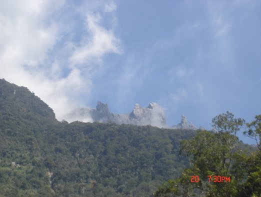
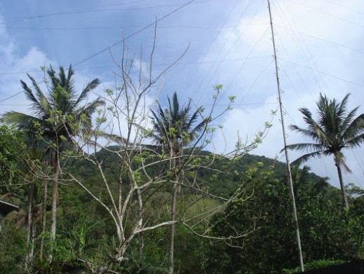
We woke up at 5AM. The group prepared, then headed to the cab station that will drive us to the jump off area of Mount Kinabalu. We rented two taxi cab for the whole group and we started to travel at 7AM. While on our way to our destination, we had a chance to see the beauty of Kota (“Kota” means city) Kinabalu, we also stop in Mount Kinabalu lookout viewpoint where we experienced to see the beauty of the mountain from a far. All of us are amazed on what we saw. And I myself realized and asked myself, “Is this the mountain that I am going to climb? Can I really climb that mountain?” I cannot believe myself either and along the way, I am fighting and convincing myself that I can do it.

Mount Kinabalu from a far (photo copyrighted by Jimmar Lagazo)
Mount Kinabalu View while we are on the road

Mount Kinabalu from lookout view-point (photo copyrighted by Jimmar Lagazo)

Mount Kinabalu peak from lookout view-point (photo copyrighted by Jimmar Lagazo)

Mount Kinabalu from lookout view-point

Next, we pickup our three guides for our trek. Then, we drove to the jump off station. Before we start our climb proper, one of our guide made an orientation and explained the trail path that our group will take. Mount Kinabalu has two trail; Misilau and Timpohon trail. The group plan is to ascend the mountain by Misilau trail and descend it through Timpohon trail. During the orientation, our guide gave us our packed lunch which was part of our reservation paid in Laban Rata, a hotel near at the peak of the mountain where we are going to stay for the night before trekking the final trail to the summit of Mount Kinabalu.

Views while on our way to jump off area

Mount Kinabalu (photo copyrighted by Jimmar Lagazo)

Entrance to Kinabalu Park (photo copyrighted by Jimmar Lagazo)

Misilau Trail jump off site


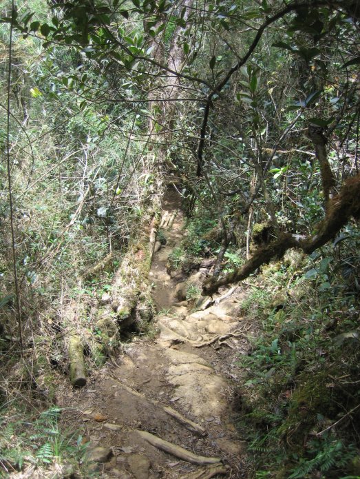
Trails to Mount Kinabalu Peak

We started our climb at almost 11 AM. The journey had begun. While climbing the mountain, I had a lot of experiences. The great thing about it was seeing the beauty inside and outside the mountain. Mount Kinabalu is a protected mountain, and most of our trails were covered with towering trees that was why we were not bothered by the sun rays.


Some trail pictures (photos above copyrighted by Jimmar Lagazo)
View while trekking the mountain (photo copyrighted by Jimmar Lagazo)
Trail View (photo copyrighted by Susan Reyes)

During the trail, we experienced rain from some point of the mountain. And I cannot forget the part wherein its raining and the trail was some kind of muddy, then there were lots of irregular stairs that we need to take. At that point, I hated stairs (but I have to deal with the stairs whether I like it or not). During that time, wind was powerful and I felt the cold because my jacket was wet due to rain even I used my raincoat. After climbing of more than seven to eight hours, I had some difficulty to climb the mountain. But I know I can still climb. But I brought a lot of water which adds to the weight of my backpack. Our team lead in the climb, asked me. “Can you still carry your backpack?” And I said, “Its ok, I think I can”, but what he did was asked one of the guide to get my backpack and port it from there to hotel. I did not object maybe because I am tired too. And I can see that it’s also the same thing felt of my group about me. Another three hours passed before we reached the hotel. To be honest, I am the last person to arrived the hotel. All of my group member were asking me if I was ok and I said to them that I was fine. For me that was both wonderful and difficult climb that I had.


some of the views to see while climbing the mountain


one of the view that we found while trekking the mountain


amazing views that we passed while on the small bridge


The hanging bridge

View from the hanging bridge
(photos above copyrighted by Jimmar Lagazo)

Laban Rata hotel for what I know is located between 3200 to 3300 meter above sea level (masl). I never realized that I was able to climb more than 3000 masl. When I arrived at hotel, that was almost 10PM. And the next climb proper to the peak of the mountain will start around 2:30 AM (I am thinking, how many hours of rest before that time).


Laban Rata Hotel
Laban Rata Hotel – where we stayed before trekking the final summit of Mount Kinabalu
(photos above copyrighted by Jimmar Lagazo)

During the dinner, the group discussed that we were all surprised of long hours of trek and all of us chanted that was really tiring and difficult climb. I can see in my team, that all of us had a great deal with Mount Kinabalu. We were thirteen in the group and only three people decided to climb up to the peak of the mountain that night. I myself, decided not to force to go to the peak. I am really tired and I know I can if I had enough time to rest, but four hours was not enough for me to have another climb. After the dinner, the group went to the room then went to bed with a decision that most of us are not going to climb up to the summit.

Day 3 – September 23 (Monday)

Around 1:30 AM, I just felt the team lead of the group woke up and tried to ask the sleeping group, who will be the other to join him to go for the summit. And then, one by one were starting to moved around and woke up. And I heard them that they were decided to go. Out of 13, 10 decided to go. And I am not one of them. Then, there was a part of me telling me to try. I can go back to the hotel if I can’t really make it.

The group that will go for final ascent left the hotel around 2:30 to 3AM in the morning. Then, I decided to follow, after that, when I got out I felt the cold wind in my body and in my face. And tried to follow the trail together with other two co-mountaineers in the group. Then, I brought my oxygen canister, because I know that air in the summit will be thinner and will be difficult for me to breathe. Then, I started to climb again, but few meters from the hotel, my oxygen canister fell and I had to look for it. Then, I become skeptical if I will go further or not. I think twice and got confused. After I saw my oxygen canister from the ground I tried to continue the climb, few minutes I felt difficulty in breathing and I realized that I have to stop. I have to stop trying and go with others. I thought that I am so much tired and I have more than 6 kilometers to descend (I need to reserved that energy). I went back to the hotel and on my way back, I told the couple mountaineers (they decided to go to the summit too) but when they saw me, they went back to the hotel with me and decided not to go further too.

At the room, there was a part of me that I wish I can go to the summit. But, I know my self limit. And be realistic that when I got outside, I felt that its hard to breathe. We slept few hours and woke up after hearing that the group arrived from the summit. 5 out of 10 (decided to go to the summit) were able to reached the summit. Some reached the other peak of the mountain. I congratulated all of them, because I know that at least some of the group were able to finish up to the summit of the mountain. We had our breakfast and started to descend the mountain.


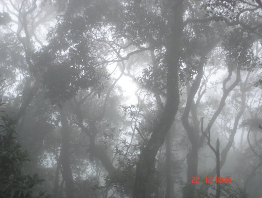
Inside the mountain while descending it (there was fog)

Carson Falls in Timpohon trail

We were able to catch up the lunch (which serves as our lunch/dinner) that day. And then rest for a while before going back to the city. Our guides gave us our climb certificate. My certificate indicated that I was completed the 3500 masl climb and for me that was really awesome. I know that Mount Kinabalu highest peak is 4095 masl. I am still proud of myself that I able to climb a mountain with that altitude. For me it was an achievement.

Mount Kinabalu is a beautiful mountain for me. It has a very friendly trail especially the Timpohon trail. While we were on our way descending the mountain, we saw a lot of tourist taking that trail to climb the mountain. Unlike Misilau trail, we just saw two which tried to descend the mountain.

Mount Kinabalu has amazing peak and the shape of the peak is really fantastic. One of the mountaineers in our group able to capture lots of pictures at the summit after reaching it. And after I saw them, the view were really panoramic. How I wish I was able to reach the summit too. But I can try to climb the mountain again next time if there will be another opportunity.

For a beginner like me my team recognized and told me that I was pretty good during the climb.

Because of all experiences I had in this mountain, I will never forget “Mount Kinabalu”.