Tumon – Beach and Urban Walk

As what I mentioned from my previous post about my adventure in Guam, Tumon is the most tourist populated area in the island as it is the place where most hotels are located, shopping district, tourist spots, beaches and where the public transportation is available. During my last day in Guam, I did a walk in some beaches in Tumon Bay and had few times walking around Tumon.

Beach Walk

After I rested a bit from my hiking and snorkeling adventure in my last day in the island, I decided to walk in the beach since the island is famous on its beaches. My walked started at Ypao Beach and ended at Matapang Beach Park. One thing that I am not sure during the walk if I should not allow walking along the shore of private beaches or it was just fine at all since all of them are along Tumon Bay.

Ypao Beach (Gov Joseph Flores Beach) Park

From the hotel that I was staying, I took a bus to Hilton bus stop and from there I walked towards Ypao Beach.

IMG_2198_s

IMG_2199_s

The beach itself has historical significance in the island. Based on history, Ypao has been inhabited 3000 years ago. But during 1680, Spanish burned the village and move the Chamorros to Hagatna as part of population centralization.

IMG_2200_s

IMG_2203_s

IMG_2206_s

Hilton Resort Guam & Spa

IMG_2208_s

During American period, Ypao became leper colony and hospital has been built due to leprosy, gangosa and insanity disease.

During Japanese regime, there were pill boxes built around the area and even along the shorelines.

This slideshow requires JavaScript.

After Ypao Beach, I passed a private beach which part of Pacific Islands Club Guam, Pacific Star Resort & Spa and Fiesta Resort Guam. Then, I also passed the San Vitores Beach before I ended in Matapang Beach Park.

Pacific Islands Club Guam

IMG_2210_s

IMG_2213_s

IMG_2214_s

IMG_2218

IMG_2221_s

This slideshow requires JavaScript.

Pacific Star Resort

IMG_2225_s

IMG_2229_s

IMG_2231_s

This slideshow requires JavaScript.

Fiesta Resort Guam

IMG_2232_s

IMG_2233_s

Matapang Beach Park
IMG_2234_s

IMG_2235_s

I was surprise that there is one such name of the beach in Guam that sounds familiar to me. The name itself is a Filipino word “Matapang” which means “brave”. I am wondering if it’s really a Filipino word or probably just similar to Chamorro word but I did not find answers to my thoughts so I just stick to its meaning based in my local language. Anyway its a name of the beach.

Before I fully passed the beach, I found the colorful canoes in the ground and looks like there is an existing club for kayaking or canoeing in the said beach.

IMG_2236_s

I ended my beach walk at Matapang Beach Park and from there, I just walked towards my hotel along Pale San Vitores Road.

IMG_2237_s

Urban Walk

In most of my travels, I always plan to get accommodation around the city where the public transportation is most accessible since I don’t know how to drive. When I visited Guam, I decided to look for hotel around Tumon. The hotels in the island are quite pricey and since I will be staying in the island for almost a week, I have to get the most affordable accommodation that I can afford at the time of visit but still located in Tumon area. In the end, I ended up to stay in Grand Plaza Hotel.

Since the first day that I stayed in the hotel up to my last day in Guam, I had few times walks around Tumon. Going to the shopping districts does not require me to take a transportation which is very handy for me to do it anytime. And if I wanted to eat somewhere not far from my accommodation, I will not have difficulty to do so.

Here are some of the photos that I captured while walking around Tumon area specifically while walking along Pale San Vitores Road.

Pale San Vitores Road

IMG_1951_s

IMG_2288_s

IMG_2289_s

IMG_2297_s

Tumon Sands Plaza

IMG_1957_s

This slideshow requires JavaScript.

Castaways Tiki Bar & Island Grill

IMG_1949_s

Park Arcade

IMG_1954_s

This slideshow requires JavaScript.

Hyatt and Sandcastle

IMG_1950_s

The Plaza Shopping Center and Underwater World

IMG_1946_s

This slideshow requires JavaScript.

IMG_2277_s

This slideshow requires JavaScript.

IMG_2287_s

This slideshow requires JavaScript.

T Galleria By DFS and The Plaza

IMG_2283_s

IMG_2290_s

This slideshow requires JavaScript.

JP Superstore

IMG_2293_s

ABCs Store

IMG_2294_s

IMG_2295_s

Notes:
1. Plan to explore Tumon Beaches ? – No general information as Tumon Bay is surrounded mostly of hotels where its front beach becomes private beach.
2. Public Transportation to Ypao Beach (Public Beach)
If you are staying in Tumon, there is available public bus that stops at YPao Beach just at the front of Guam Visitors Bureau, then walk towards the public beach
Ticket Fare : As of April 2017, one way ticket is $4.00
Additional Resources : guam-beaches.com

Twilight : Sydney Harbour Bridge

Twilight (Post#7) : Sydney Harbour Bridge

What can I say about this bridge? It is famous every time the new year is celebrated in the city as usually fireworks display held in the bridge. It’s fascinating to see the night version of this bridge. The photo is part of Sydney Walking Tour April 2014.

IMG_4581

Twilight : Manly Beach

Twilight (Post#6) : Manly Beach

When I visited Manly Beach, it’s already dark, therefore I haven’t seen it in day light. Due to limited time, I had been content in walking in the beach at night. The was named by Captain Arthur Phillip describes the indigenous people’s with confidence and manly behaviour and named it as ‘Manly Cove’. The photo is part of Sydney Walking Tour April 2014.

IMG_4819

Theme : Beach – Coogee Beach

Theme (Post#9) : Beach – Coogee Beach

The last beach I reached for the walking trail that I took is Coogee Beach. The volume of people I found in Bondi seems to be similar in Coogee. And seeing people in the beach, everyone was having a great time. The name of Coogee is said to be taken from a local Aboriginal word “koojah” which means “smelly place”. The photo is part of Sydney Walking Tour April 2014.

IMG_4782

Theme : Beach – Gordons Bay

Theme (Post#8) : Beach – Gordons Bay

This is one of the beach that quite unique because its not similar to the beaches that I found in my walk as this one is where The Gordons Bay Underwater Nature Trail can be found which is the spot for self-guided for snorkeling and scuba diving adventures. The photo is part of Sydney Walking Tour April 2014.

IMG_4773

Theme : Beach – Clovelly Beach

Theme (Post#7) : Beach – Clovelly Beach

So far, I already enjoyed three beaches, my walks hasn’t stopping yet. As I see the walking trail still there, my pace continues. I was amazed about the trail. And I still surprised after I found the fourth beach in front of me and that is Clovelly Beach. The beach was known as Little Coogee and renamed after the village of Clovelly on the north Devon coast, England. The photo is part of Sydney Walking Tour April 2014.

IMG_4765

Theme : Beach – Bronte Beach

Theme (Post#6) : Beach – Bronte Beach

So my walk continues after passing Tamarama Beach. I never expected that the walk will give me a chance to see different beaches in Sydney. I admired the city as it does not have only one beach near the metropolis but more than that. Anyone can immediately see a different sceneries aside from city buildings by just few kilometers driving from it. The name of the beach was came from Duke of Bronte, military figure Vice-Admiral Horatio Nelson. The photo is part of Sydney Walking Tour April 2014.

IMG_4741

Theme : Beach – Tamarama Beach

Theme (Post#5) : Beach – Tamarama Beach

After enjoying my walk around and after appreciating the fascinating views of Bondi Beach, my pace moved forward not knowing what’s next to see or discover. Then, I saw another shore similar to Bondi but smaller one. And I saw there were people swimming, surfing and just lying on the ground beach enjoying the sun. I just reached Tamarama Beach in Waverly an eastern suburb of Sydney. Tamarama came from aboriginal word ‘Gamma Gamma’ which means ‘Storm’. The beach is also considered the most dangerous patrolled beach in New South Wales. The photo is part of Sydney Walking Tour April 2014.

IMG_4733

Enclave at East Melbourne – A Classical Residential District of Melbourne – Melbourne Walking Tour – Part 9

By just learning the year the houses and buildings were built and seeing these houses still standing today is already a proof they survived more than a century. Now I understand how state of Victoria able to preserve these houses. Though there are some units that already demolished and we cannot see them today, there are still building and houses that survives, a truly treasure that should be kept and maintain.

Another Saturday of June 2013, I did a walking experiment while living in Melbourne. That time the one that I did was taking the stroll of what they called Melbourne Walks – Elegant Enclave. The word it used is quite intriguing because it used ‘Elegant’ which pretty much sure that it also connotes with wealth and luxury.

From the people who I had met and made friends in Melbourne, they told me that East Melbourne is part of Melbourne where rich and wealthy people lives. And with that said I became curious in this part of the city and after the walk, I can say that there is evidence of what my friends are telling me, and its historically.

I brought the map brochure that I got from Visitors Centre at Federation Square as my guidance to see and discover the ‘Elegant Enclave’. I started my discovery after passing Fitzroy Gardens and Clarendon Street.

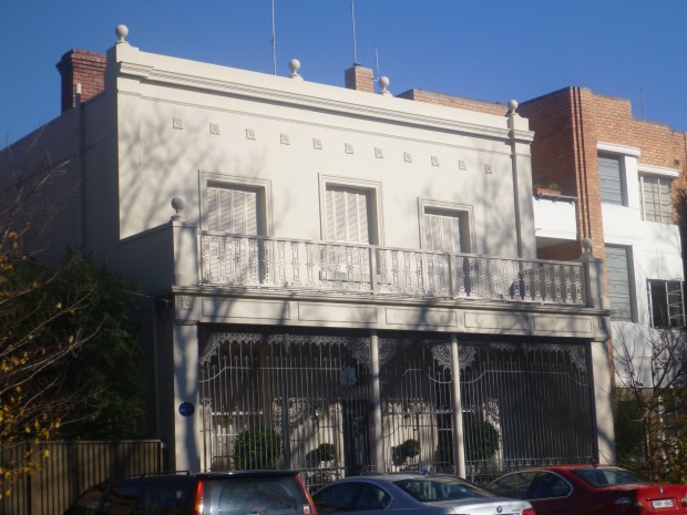
Hepburn Terrace (No 199–209 George Street)

Not far from the corner of Clarendon Street and George Street, I found Hepburn Terrace – a six two-storey terraced houses. These houses were built in 1855, 1867 and 1872.

p1090685

Along George Street, there are many mansions that can be found here according to the map and to be honest, I myself got confused which one was really mentioned in the map. So spare me if not all photos of the buildings in the map was not here as I am not able to capture them all.

1920s Post Office (No. 24 George Street)

Former post office built in 1920s and stands at 24 George Street. This building seems to be the youngest building that I am including in this post, even though this one is more than 80 years old.

p1090692

p1090693

Georgian Court (No. 21 George Street)

Built as apartment in 1860, currently the building becomes Georgian Court Bed & Breakfast. The building survived for more than 150 years now. Quite impressive historically. Another discovery for this building is, it was city base home of famous Australian operatic soprano named Dame Nellie Melba (Melba was pseudonym from Melbourne).

p1090690

No 49 George Street

The building was once home of Melbourne’s first surveyor, Robert Russell in 1865.

p1090688

p1090694

Queen Bess Row (corner Simpson and Hotham Streets)

It’s a three four storey houses of red brick with sandstone dressings and the first fully developed example building built in the Queen Anne Revival style. The building initially became The East Melbourne Trained Nurses’ Home and private hospital from 1890 until 1894. Then, it become apartment – first apartment block in Melbourne.

In 1920’s, the building were known as the following: Rubra Flats (72), Angus McArthur’s boarding house (74), and Cregh Flats (76). In 1936 No. 74 was known as Tudor Guest House.

In 1989, the building stop as boarding house and were sold in three separate houses in 1990.

p1090696

Dorset Terrace (No 114 – 120 Hotham Street)

Four terrace houses erected in 1883 with front doors unusually placed diagonally to the gates. This is notable terrace in the boom classical style.

p1090707

Cairns Memorial Presbyterian Church

Presbyterian church built in 1895 but due to fire happened in 1988 where the shell of the building are the only remains, it was converted into luxury apartments.

p1090727

Opera House – Opera Box Style Balcony (No 138 Powlett Street)

Because of opera-box style balcony, the building has been called as Opera House which was built in 1868.

p1090712

Terrace House (No 130 Powlett Street)

Tuck-pointed terrace built in 1867 for Stephen Trythall, headmaster of Trinity Public School, corner Victoria Pde.& Hoddle St. – later National School.

p1090713

Crathre House (No 118 Gipps Street)

The building was built in 1874 and has busy history over a century since then and along with it, the name Crathie became Crathre with no particular reason but due to confusion or misunderstanding.

1898-1902 – the Bungalow house function as family home at first, then become a lodging house
1902-1904 – Sir John Monash and his wife become residents of the house
1904-1914 – it become boarding and lodging house again.
1924-1933 – called as Crathie House Private Hospital
1933-1969 – the building become apartments
1969-1980 – it was intended to demolished but it provoked a storm of protest from the National Trust, the East Melbourne and residents where the campaign against it was successful

p1090714

p1090715

Nepean Terrace (No 128 – 132 Gipps Street)

A terrace of three two-storey houses in Regency style and built in 1863. While searching about the history of the building, there is one thing that caught my attention. One of the history owner of the residence was Frederick Baker, known professionally as Federici, singer by profession whom died in Princess Theatre in March 1888 after the stage act due to heart attack.

p1090718

Townhouse (No 179 Gipps Street)

They described it as

“A fine two-storeyed house in the Italianate manner with delicate stucco detailing and well proportioned openings”

and was built in 1861. The building was the townhouse of Constance Stone, who became Australia’s first woman doctor in 1890.

p1090719

p1090720

Little Parndon (No 159 Gipps Street)

This building was built for the Austrian born, landscape painter, Eugene von Guerard in 1862 who was prominent artist and teacher in the late 1800s. Based from history, it is uncertain who named the house ‘Little Parndon’ but the name was in use by 1937. The original Little Parndon was a village in Essex, now incorporated in the town of Harlow.

p1090721

No. 155 Gipps Street

This building built in 1863 and artist-author Norman Lindsay (who wrote The Magic Pudding) courted first wife Kate Parkinson in the 1890s.

p1090722

Canterbury Terrace (No 82 – 112 Powlett Street)

A row of 16 terrace houses of five bays built in 1878, it is Melbourne’s longest terrace, with 16 homes. While reading its history, the one below got my interest.

“Local belief is that one of the houses held the lodgings of Brian Fitzgerald, the main character and early murder suspect in the best-selling book, Mystery of a Hansom Cab, written by Fergus Hume in 1886. The house is described only as being in Powlett Street near the Cairns Memorial Church.”

p1090723

p1090724

House (No. 85 Powlett Street)

It was home to Peter Lalor, who led miners in the Eureka Stockade uprising at Ballarat in 1854 and became Speaker in the Victorian Parliament, an interesting facts to learn.

p1090729

The Gothic House (No. 157 Hotham Street)

An 1861 bluestone home dubbed The Gothic House. It was designed by architect Joseph Reed (who designed Melbourne Town Hall, State Library and Royal Exhibition Building) for deputy surveyor-general Clement Hodgkinson (who designed the Fitzroy and Treasury gardens).

p1090730

Fairhall (No. 154 Hotham Street)

The house was built in 1860 and an elegant townhouse at the same year. One of the owner was William Robert Johnston, antique dealer and collector. He changed the name of the house to the more euphonious Fairhall. It is now now the home of The Johnston Collection.

p1090735

© THE HIDDEN PANORAMA 2017

Cyprus Terrace (No. 158 – 164 Hotham Street)

Built in 1867-68 and was designed to look like two grand houses but is actually four homes.

p1090737

Bishopscourt

Bishopscourt is the official residence of the Anglican Archbishop of Melbourne. It is used as the residence for all of Melbourne’s Anglican diocesan bishops and archbishops. From 1874 to 1876, it was used as Victoria’s Government House.

p1090739

p1090741

Additional:

Below are the other buildings that I were able to capture some photos but not included in map. Here’s some information of it.

Mosspennoch (No 22-40 Clarendon Street)

The building become heritage building as the architect of this is the same who design Royal Arcade – Charles Webb (please see my post about  Royal Arcade here).

p1090684

Janet Terrace (92-96 Hotham Street)

Named after Janet Clarke, second wife of Sir William John Clarke. His father, ‘Big’ Clarke was allegedly the father of William Maloney. William Maloney was a medical doctor who became Australian Labor Party member of the Australian House of Representatives for 36 years.

p1090703

p1090702

Magnolia Court (No 101 Powlett Street)

A two storey, freestanding house with a modern extension to the southern side built in 1861. Now a boutique hotel.

It was Ormiston Ladies College. In the early 1900s, Magnolia Court was home to those involved in Melbourne’s theatre and the early days of the Australian Ballet.

In 1951 the property was re-named Magnolia Court after the impressive magnolia tree that once graced the front garden.

p1090725

p1090726

No 10-14 Powlett Street-Group

Three similar terrace type houses of 1886 with elaborate architectural treatment which includes a pedimented gablet in the balcony roof and ornamental iron brackets of unusual design.

p1090686

Credits:

Historical research information are mostly came from East Melbourne Historical Society and Victorian Heritage Database

Notes:
1. Plan to visit East Melbourne or wanted to do the Melbourne – Elegant Enclave ?
Please visit Visitors Centre at Federation Square and pick the Elegant Enclave Walk or download the walking map tour here.

2. The walk is free and can be done at your leisure time

3. Public Transportation Ticket – Use Myki (Melbourne Ticketing System), please check here for more details.

4. Directions

To Visitors Centre at Federation Square:

Using tram

Use tramTracker Apps or even just Google Maps (use directions) and there are tram routes available
Route: 1, 3/3a, 5, 6, 8, 16, 64, 67, 72 –> get off at Stop 13 – Flinders Street
Route 19, 59 –> get off at Stop 4 – Federation Square

Using train

Ride from any station and get off at Flinders Street Station

To East Melbourne:

Using tram
From Townhall/Collins Street
Route: 112, 109 –> get off at Stop 16 – Wellington Street
Route: 48 –> get off at Stop 11 – Jolimont Station

From Swantons Street and Flinders Street
Route: 75 –> get off at Stop 11 – Jolimont Station

Using train
Take either South Morang Line or Hurstbridge Line and get off at Jolimont Station

Featuring Our World : Bondi Beach

Featuring Our World (Post#3) : Bondi Beach

During my 4th time visit in Sydney which happened last April 2014 during my 3rd project assignment in Australia, I planned to explore a bit Sydney and some nearby outskirts of the city. One of the places that I explored by walking is the famous Bondi Beach. Honestly I was just curious because I always heard the beach many times while staying in Australia for more than 1.5 years. And I never able to really got a chance to see the beach even I had been in Sydney for quite times. And because of that, I really grabbed my chance to see it.

As I learned that Bondi word is actual an aboriginal word (local word of one of the first people lives in Australia). “Bondi” means “water breaking over rocks” which you can notice that while in the beach and the nearby rocky parts between the side of the beach. I can say that the beach is famous because anyone can visit it easily through any means of transportation as it is not far from Sydney central business district, therefore, people can immediately appreciate the beach without being far or away from the city. Based on history, Bondi Beach has been one of the location during Summer Olympics in 2000 when Australia won over Beijing China. And the beach is also recognized as one of the landmarks in Australia.

I got a chance to see Bondi when I planned to explore Sydney by walking and it happened when I did a walk from Bondi to Cogee.

This slideshow requires JavaScript.

Bondi Beach (Part 1)

This slideshow requires JavaScript.

Bondi Beach (Part 2)

This slideshow requires JavaScript.

Bondi Beach (Part 3)

This slideshow requires JavaScript.

Bondi Beach (Part 4)

This slideshow requires JavaScript.

Bondi Beach (Part 5)

Meandering At Kings Canyon’s Wilderness

My second day was mixed of Kata Tjuta, a bit of Uluru and Mount Conner. So far I was floating in satisfaction and fantastic scenery and experiences. At first, I thought that the group’s next destination was just nearby until we spent more than two hours in the road. It was like the same feeling during my Day 1 trip, I felt the time passed was too long but in reality it was not. Before arriving to Kings Creek Station we passed a beautiful scenery of George Gill Ranges located at our right side while we were on our way to Wattarka National Park from Lasseter Highway. I really enjoyed the scenic views for some time since it is a long mountain range. At that very moment while enjoying the scenery, I felt that part of the world like heaven in a sense that it was a peaceful moment of my life.

P1080124

P1080122

At Kings Creek Station

P1080123

Our Tour Bus


Camels found at Kings Creek Station

We reached our destination, the Kings Creek Station and Kings Canyon was just around the corner. I remembered, our tour guide mentioned that our second and last night accommodation was an upgrade from the first one. He told us that from swag, we were upgraded to tent, a tent with bed. With that thought in mind, I expected that the tent is not the same tent I used in my hiking adventure, because a bed will not fit on it. We got off the bus and noticed that we stopped in a gas station, we walked around the area and familiarize ourselves in the place.

The good thing about the place, it has store that you can buy basic things needed in the outback and even gifts or souvenirs. Then we passed the shower rooms and bathrooms. We walked to the area and found the version of the tent that I was thinking. Then, I realized that the tent that our tour guide was referring to, was called safari cabin. Two single bed are fit in a cabin. Therefore we have to find our partners for each cabin and I found mine but apologies as I can’t recall her name right now.

After we took our stuff from the bus, we arranged ourselves at the cabin and made ourselves comfortable. I arranged my bed and my stuff, then, I went out to help the group for our dinner. That night, all of us in the group were helping out. Another thing that I noticed was that our tour guide knows a lot about food. Even we have members in the group that are vegetarians, breakfast, lunch, snacks and dinner were not been an issue to him. I learned something about food wrapping. Learned that having stuff to fill in the wrap, you are ready to fill in yourself without really cooking. Another thing that I discovered was cooking using charred wood. There was a bonfire area just near from our cabin which also used for cooking. I was familiar with cookware, pans or pots used for cooking but the new stuff for me was pots where it’s lid has a portion on its top area where you can  place burned wood wherein the heat was not only coming from the bottom of the pot but also on its top to make cooking easier and faster. It was an amazing stuff that I discovered and a very important cooking pots or basins when you wanted try to live in the outback.

P1080125

Bonfire


Cooking Basins

That night, we prepared a lot of food. Maybe because it was our second and last night together in the outback. I snapped the idea because it made my feelings gloomy. We still have the next day for the last adventure. We cleaned-up the kitchen and the dishes we used in preparing and cooking our food.

Maybe because it was our last night together, most of our group did not sleep immediately after the dinner. We sat around the bonfire we used in cooking for our dinner and we started talking together. At that moment in my life in front of bonfire at the outback together with the people I had been with for the past two days feel like a familiar feeling, though we’re all still strangers personally but I felt it was like home. I knew that it may not or may take longer that moment to happen again, and every bit of it, I treasured the moment in my heart and my mind. We spent hours in front of bonfire and then, one by one were saying good nights. I was one of the last person to stand away from bonfire and went to the cabin.

I felt relaxed when I returned to the cabin and in a matter of minutes I was dreaming. I walked up early in the morning, had our breakfast, cleanup the dishes and ready for the last day adventure. For our third and last adventure, I was still excited because we were scheduled to walk and trek around Kings Canyon. One of the canyon I saw was a long time ago and that time I was inside the rocky mountaineer train which was Cheakamus Canyon in Canada. I felt excited and inspired to see and experience Kings Canyon.

All of us jumped into the bus and drove towards the canyon. From Kings Creek Station we reached the parking area. Our main activity was to walk within the canyon. We followed the Canyon Rim Walk track with estimated of 3 to 4 hours of walk and trek. Our tour guide gave us a warning that the initial part of the trail is called a “heart attack” hill because we have to climb a steep and rugged steps (stairs) which he mentioned as 45 degrees. This means the climbed in that stairs will be a bit of exhausting.


Scenery enjoyed while resting after the heart attack trail

We walked a bit until we reached the uneven stairs. I saw the trail and I saw that it was a bit of steep climb. I knew it was a quite challenging climb because even though there’s a rugged steps, for me it’s more challenging to climb a stair than climbing with your own steps. When I did the climbed, I remembered that I was catching my breath. I looked-up and checked if the last step of the stair was almost near. I rejoiced when I saw that I was almost at the top of the stairs. The warning given by our guide was right, it was a heart attack climbed. It was not that really difficult like my other climbs that I had, it’s just that everyone were pushed to follow the steps of the stairs. So there’s a bit of time than I rested to recover my breathing. When we reached the top, we stopped a bit so everyone in the group will be gathered again. What I saw at the top excites me because I knew that we were exploring a canyon in the red center of Australia.


Our tour guide explaining something about sand dunes and rocks

When everyone were at the top area after the heart attack trail, our tour guide started to tell something about the canyon and its sand dunes. He mentioned that there were other trails available in the canyon and we were taking the trail that will finished just after lunch time. Next, we enjoyed the walk within the canyon wherein I just realized we were actually walking in the weathered sandstone domes that looks like the Lost City when we were at the other side of the canyon.


Snapshots while walking in between of weathered sandstone domes  which called Lost City of the canyon and while resting a bit not that far from the heart attack trail

We walked, ascended, then we repeated the process until we reached the famous lookout within the Canyon – Cotterrils Lookout. The said lookout gave us a chance to see 365 degrees of the canyon. We had a wide view of the Kings Creek and the overall scenery of weathered sandstone domes. In the said lookout we spent time here for photos and funny posts that our guide suggested us to do as our memories of the canyon.


Around or near Cotterrils Lookout


Cotterrils Lookout


While at Cotterrils Lookout


Lost City like scenery from Cotterrils Lookout


Kings Creek

Our walk in the canyon allowed us to discover the area of the canyon where there was a spot that was similar to Bungle Bungle (included in my list to see in Western Australia – I hope I will got a chance to tour around that state).

P1080202


The Little Bungle Bungle within the Kings Canyon

After enjoying the scenery of the sandstone domes, our trek within the canyon continued. We reached the wooden stairs and we descended and followed the track. Next we crossed the bridge. Then, we reached a gorge between cliff. While following the track after the stairs we saw what they called Garden of Eden because it serves as oasis where there are natural spring waterholes and has different plants around the area.


The Wooden Stairs and Bridges


Garden of Eden


Before we climbed up at the other side cliff we rested at the Garden of Eden near the oasis. Aside from us, other visitors stopped there too and there were few young male teenagers who jumped off in the oasis and enjoyed their swimming. While we’re resting our tour guide gave us some snacks that the whole group shared.

After resting we returned in our track and we climbed up the wooden stairs. When we reached the other side of the canyon, it gave us a chance to see the canyon in a different outlook or perspective. The part of the canyon that we just walked by and passed by, we were able to see it from the other end what it looks like. The rock domes are more notable compared to when we were walking along with it.


While climbing at the other side of the cliff


Rock Domes


In between Rock Domes


Waterhole

At the top we saw the oasis in a different angle even and the same with Kings Creek. Our walk continued. After sometime, we saw the part of the canyon that showcase another view of weathered sandstone. That weathered sandstone from a far looks similar to Old Aztec City that is why it is being called as Lost City.


This slideshow requires JavaScript.

Kings Creek


The other side of the wall of the Kings Creek in Kings Canyon


This slideshow requires JavaScript.

Lost City in Kings Canyon

DSC04959

DSC04960

At the top, we spent more time for photos, selfies, groupies with the wonderful scenery that surrounds us. And then, our tour guide announced that we will start descending the canyon. We started our walk and followed our guide. With that moment, I know that once we reached the ground, that’s the last moment that I will have with the canyon. Probably with other people it’s just another canyon to see and visit, but for me the outback as a whole was another world for me that I may not be seeing again, but the place gave me a lot of memories because I was given a chance to discover and explore them in a short period of time. I somehow thinking that if I am not an IT (Information Technology) by profession I maybe a geologist. It may be an interesting profession.

When we touched the ground, we had our pack lunch and we headed straight back to Alice Springs where we started our 3 days adventure in the outback. I spent another night in Alice Springs and returned to Melbourne the next day.

Below are some photos that I still have after reaching Alice Springs and on my way back to Melbourne.

DSC04980

Back to Alice Srings


With Wallabies


Alice Springs Airport

Note:
This is the 3rd or last part of my travel post and the continuation of my adventure of the Red Center in Australia. It takes a while for me to finish the post as I am overwhelmed with so many places that I traveled to and half of the post was done last year and now I got a chance to finish it up as I also tried to remember everything not only from photos and but also from all the experiences that are still in my memory.

Here are the other 2 posts from Australia’s Red Center which already published.
Uluru / Ayers Rock
Kata Tjuta (The Olgas)

Ginza – Tokyo’s Popular Shopping District

Before ending our first day in Japan, my sister and I decided to walk a bit in areas near the hotel leaving our parents behind and let them have enough rest. Our accommodation was located strategically in Central Tokyo,  as it is accessible via metro subway train. While walking we got a chance to see some part of Tokyo at night. It was Friday night, we left the hotel for a walk around 8PM in the evening. We walked along Eitai Dori, then we turned left and continued the walk along Chuo Dori. Here, we saw line of buildings where most of the ground level are stores and restaurants. Some buildings are malls. Along Chuo Dori, I already enjoyed the lined-up of buildings in it. Though we only did a quick walk, the impression I had while passing the buildings, I felt the relaxing ambiance of the surroundings even though it’s an urban place, though I’m not sure if the feeling is the same case during  the day.

We walked at Chuo Dori because it leads us to Ginza where one of the popular shopping district in Tokyo can be found. As the peak hours had passed, we haven’t seen too many people in the road. Probably some just began having good time with their Friday night or majority of them gone home, leaving the downtown for the weekend for a while. During the walk, my sister and I observed that people we passed by looks like they came from work as both Japanese men and women were in their professional dress code. One thing to note, the fashion style we noticed specially for Japanese women from hotel to Ginza area were wearing modern and yet conservative clothing because most of the dress or skirt length they wear were up to knee-length. Honestly, I like the way they dress because it shows their character and values of simplicity.

Our walk that night, made me amazed because in simple thing that I witnessed, the discipline that Japanese has in crossing the road. Even the road is like an alley and even no vehicle is passing through, if its red light they really stopped and waited for green sign to cross the road. At the back of my head, I myself practice it as well even in my country but sometimes I myself neglected following traffic rules and being impatient, some of my country men doesn’t do it, specially if the vehicle are on park mode while waiting for green light, even it was stop sign, people are crossing to almost all kinds of roads, which shows of people being impatient in waiting or let’s say people with no discipline at all even in small thing such as road crossing.

IMG_5052

IMG_5054

Chuo Dori

As we approached Ginza area, the bustling lights coming from different stores along Chuo Dori were imminent. Because the lights are quite intoxicating we took photos of ourselves with the stores, we took selfie photos, and we took some photos with the road.

IMG_5056

IMG_5057

Ginza Wako

It’s almost 9PM in the evening and we were looking for western food chain like Mc Donald’s or KFC as we were hungry (we’re not really type of people who adventures local food but we’re open to taste it). From Chuo Dori road we turned right at Harumi Dori towards Tokyo Expressway then turned right again at Sotobori Dori and walked for a short distance until we found KFC. That night, we found out that food are quite pricey in Japan, compared to other countries we had visited. After dinner, we had some takeaway food for our parents. We took Metro Subway to return to the hotel, from Ginza Station to Kayabacho Station.

IMG_5062

Sotobori Dori

My impression to Ginza area, I think a lot of people will enjoy the place as there is lot to see specially if  preferences of the visitors is into shopping. The area is a place of  combined shopping centres, dining places and entertainments.

Tokyo – From A Small Fishing Village To A Bustling Metropolitan Prefecture

When I am researching information about Tokyo, there is a curiosity about the history of one of the popular or famous city in the world. Tokyo’s former name was Edo which was part of old Musashi Province (information from Wikipedia) wherein fortified by Edo clan. Edo  was a small fishing village around 18th century, but seeing Tokyo right now, as I knew that it was a city until I understand that it’s not just a city but a metropolitan prefecture of Japan. It is the most populous metropolitan area of the country and where Japan’s government located.

After seeing some part of Tokyo, knowing what it was before is an amazing thing to discover. Realizing how far it progressed from where it was before is truly considered exponential growth and success of the small village.

A Metro To Remember

The inbound flight that I was able to book to Japan was through Narita Airport. The said airport is 1 hour train to Tokyo Downtown. At first, when I started planning my family’s itinerary, Narita area was first on my list to visit while in Japan with the reason that it is near from the airport and considering utilizing our time. Then I changed the list when I was finalizing the itinerary, I replaced Narita with Tokyo.

We left home from Dasmarinas Cavite around 1AM of September 11, allotting 4.5 hours before the scheduled flight. The past few days that week in my country had gloomy weather as almost every afternoon to evening, in Metro Manila and its outskirts had been raining. We left early as we were trying to anticipate road traffic challenges that may arise if the weather will be the same. I was really glad that Friday early morning, the road was quiet as we travel on the way to the airport. We had smooth travel from home to the airport and the good thing about that morning, it wasn’t raining at all. Around 2AM we’re already at NAIA (Ninoy Aquino International Airport) Terminal 3.

At the airport, we followed the norms of people traveling international such as paying travel taxes and flight checking-in. After checked-in, since it was still early and we had ample time to spare, we had our breakfast at local food chain in the airport. Next, we went to immigration gate. After passing immigration, we went straight to the airline’s gate. While waiting at the designated gate of our flight, I was thinking about Japan. In my mind, in just less than an hour or so, I will be on my way in a country called “Land of the Rising Sun”. A country which for me was only a dream. At that moment of my life, I felt excited because soon the dream in my mind will become a reality. And the momentous about it, I’m traveling with my family.

The flight was more than 4 hours. The plane took off around 5:30AM in Manila. We landed in Narita International Airport past 10:35AM. Japan was 1 hour ahead in Philippines. We disembarked the plane and walked towards immigration section. Standing in one of the airport in Japan was the realization of my thoughts that I was really in Japan. When we passed the immigration officers, that was the time I believed we will really see and experience Japan.

After the immigration, one of the first thing that’s unique with Japan at the airport is their toilet where you have a lot of options to do aside from the normal stuff that people does. What I’m referring to is that, their toilets has options to play some music or soothing sounds while doing your business. And most of the manual stuff like flushing before and after, it will be done automatically for you. Well, in my country that’s not the case, though some malls has toilets with automatic flush after doing your business.

We were adjusting in the airport and I was thinking what’s the next thing to do, we tried to figure out how we were going to Tokyo downtown. We found Skyliner desk, Skyliner is a train line that directly goes to Nippori and Ueno Station (another option is Narita Express train line that goes straight to Tokyo Station). I chose Skyliner because our Japan Railpass was not yet activated and it has only 7 days, we will be in Japan for 10 days so we were saving the other 3 days. I also knew that we still have chance to experience Narita Express train once we return to the Airport, for our scheduled flight back to Manila. Skyliner is just one of the great trains that we were able to ride while in Japan. I bought the tickets for four and then I looked for ATM to get some money. We went upstairs  (where the departure floor is located) to pickup the pocket WiFi in Japan Post Office that I reserved for rent prior arriving in Japan, WiFi will enable us to connect to internet while roaming around the country which is a LTE connection, unlimited data and cheaper for 10 days compared if I will activate data roaming in my mobile from my country and the best of all, all in the family can connect internet seamlessly.  After I picked-up the wifi, my father told me that he lost his jacket somewhere and it seems he left it after we passed the immigration officers. My father and my sister went to Information Desk at the airport and requested to looked for the jacket. It was a good thing that we had some photos of the jacket and we were able to show it to airport officers. In few minutes of waiting, my father’s jacket had been returned to him immediately. That kind of experience in a new place was really a great thing. I appreciated how people in that place were so efficient and trustworthy that they can easily find my father’s jacket. It may be a different situation if we were in another country.

Because of the incident, we came back to the Skyliner train desk where we bought our tickets and we requested to replace our tickets as the ticket schedule has passed already. They issued us new tickets for next train which will be leaving soon. We hurriedly went down to the train platform but the train doors were already closed when we arrived and its departing, we missed it for the second time. I came back upstairs and let my family wait in the platform as it’s quite inconvenient if all of us going up with our luggage. I talked to the train officer and advised me to get new ticket. I returned to the Skyliner for the second time, the third schedule given to us was at least an hour waiting time, a very sufficient time for all of us not to miss the train. Missing the train is not really something that’s surprising for us to experience because its our first time to find the train platform and it’s also first time to ride a train in Japan.

From Narita Airport Station (because there is Narita Station which different station), we arrived at Ueno Station after an hour.  Japan is a country where train is the most common and most efficient public mass transportation. After arriving in Ueno Station, we started to use our Passmo card I bought together with the Japan Railpass. Passmo card are usable to all trains and buses around Tokyo, but it cannot be used for long travel. Passmo card are accepted to many cities in Japan, maybe in the next coming years they have one card for all transportation which I will be looking forward to in the future. I did my research about public transportation in Japan and understood that there are specific tickets for some train lines. That’s why I made sure that we have the appropriate ticket for the train line we will be taking. From Ueno Station, we transferred to Tokyo Metro Subway and took Hibiya Line towards Naka-meguro and got-off at Kayabacho Station where our hotel for 4 consecutive days in Tokyo is very near and the hotel we will be staying is Sotetsu-Fresa Inn Nihombashi Kayabacho.

Honestly, based on my plan, after we arrived in Japan, we planned to see some places in the afternoon as part of our activity to end our first day. The original plan was to visit Ueno Park, but the plan did not happen because both of my parents were already tired as we haven’t slept due to early flight that day, I decided to cancel the planned activity.

The following places we visited in Tokyo are: Ginza for the first day, Ryogoku, Akihabara for the fourth day and Ueno, Azakusa, Tokyo SkyTree for the 9th day in Japan. Detailed stories of each places are posted or will be posted separately on the link given below.

Day 1 – Ginza

IMG_5055

Day 4 – Ryogoku Kokugikan

Hidden Panorama - Tokyo Fishing Village Metropolitan Prefecture

Day 4 – Akihabara

IMG_3590

Our second and last Saturday in Japan spent another day in Tokyo. Early in the morning, we took Shinkansen train from Kyoto to Tokyo. We left Kyoto Station around 6:23AM and we arrived in Tokyo Station around 9AM. Though these two cities far from each other, the Shinkansen train made us felt that both are just near each other. The estimated distance between Kyoto Station and Tokyo Station are around 500 km and it only needs more than 2.5 hours travel within the two stations. It was 3rd time we had Shinkansen Train, though it was not the fastest Shikansen, but it still comparable in terms of its speed, for what I’m aware of the Shinkansen train we took just late of 10 minutes compared with the fastest bullet train. Because it was long weekend (as September 21 is a public holiday in Japan), I anticipated that a lot of people were traveling and we reserved our ticket a day before and it’s almost fully booked  when I reserved our tickets, the seats we got were not beside each other and one seat was in another car train. I let myself apart from my family as I can be on my own and let my youngest sister be with my parents in another car train.

When we were at Tokyo Station, we looked around for luggage locker because our hotel for the night is near in Narita International Airport. After checking-in our luggage, we roam around again for the last time in Tokyo.

Day 9 – Ueno Park and Ameyoko

Hidden Panorama - Tokyo Fishing Village Metropolitan Prefecture1

IMG_5078

Day 9 – Asakusa and Sensoji Temple

Hidden Panorama - Tokyo Fishing Village Metropolitan Prefecture2

Day 9 – Tokyo SkyTree

IMG_5221

After taking our time with photo shots in Tokyo SkyTree, we decided to go down as we need to catch-up train going Otsuka to attend an event. From Tokyo SkyTree Station in Tobu Line, we returned to Asakusa  Station, then transferred to Ginza Line. We got off at Ueno Station. At Ueno Station  I just realized that I have to cancel our travel in the place that my family need to be, due to my unintended mistake, we had to take train to Tokyo Station instead to Otsuka Station as we need to catch-up the last trip of Narita Express train from Tokyo Station to Narita Airport Station, as our hotel for our last night in Japan was near the airport.

At Tokyo Station we walked so fast as we need to find the luggage locker we used to checked-in our luggage and bags at the station. We arrived at the train platform for Narita Express train at least 5 minutes before its scheduled departure as we were catching our breath. For all of us it was really a nick of time because if we missed the train, we have to take a taxi which was really expensive coming from Tokyo to Narita.

We arrived past 9PM at Narita Airport Station. Then, we took the shuttle bus to the hotel we booked. We checked-in at the Narita Tobu Airport hotel before 10PM. Before we ended the night, we had a wonderful and delightful dinner at the hotel as both of my parents complimented the food we had that night and I felt relieved to what I heard.

We woke-up early and did last-minute packing of our luggage and checked-out the hotel. We took the shuttle bus back to the airport. We arrived at the airport, had enough time before our flight. I went back to the Post Office booth and returned the WiFi device I rented. We checked-in in our flight and passed the immigration. We went to the designated gate of our flight and waited for our departure. At that time I felt that days passed so fast. I remembered 9 days ago, we just came in to Japan and yet that moment we’re about to leave the country. I sensed that in few hours I and my family has to go back in reality of our lives again.

I had a great time in Tokyo and oveall in Japan, though there are lots of places that I haven’t seen but we had wonderful time and we had fun as Japan offered us a lot of places to see to enjoy our trip in this country called “Land of the Rising Sun”.

Until I return again.

Chromatic Outlook : Queen Victoria Building

IMG_4440

Chromatic Outlook (Post#15) : Queen Victoria Building

As part of my walking tour in Sydney Australia which is my 4th time visit in the said city, I got a chance to enter and explore Queen Victoria Building. As I realized touring around Australia, I saw similar style of its interior in different part of Australia. Though the said building is much bigger or probably let say more levels than other arcades that I saw in Melbourne, Adelaide and Brisbane. The hallway is in the middle and different stores are on it’s both lanes. I like this building and other arcades because every time I go inside similar places I felt the ambiance of turning back a hundred years ago because of the external styles of the stores which designed in 19th century. And I admired Australia for being able to keep such stores and able to maintain historical design and style of 18th to 19th century markets with a little bit of touch of our time. Photo captured last April 2014.


Walking and Trekking at MacRitchie Nature Trail and Reservoir

Year 2008 was the year that reminded me or let say reawakened in my self that I love nature. I love greens and forest and that led me to love mountains. When I moved to Singapore for work I knew that I am sacrificing one thing that I love that is climbing a mountain.

Singapore is a city, though it tried to maintain itself as being green city still it does not have mountains to climb. I remembered that there is one mountain that I know and that is Mount Faber where one end of Sentosa cable car is located. Aside from that mountain, I know nothing else.

When I started working in Singapore I thought that things will get excited because living in another country different from what I used to be might be an adventure. I started working in Singapore last December 2009 and to my surprised less than a month or exactly after a month, I felt bored. My colleagues at work started to feel the same way, in another two months all of us felt home sick.

I belong to a batch of IT Filipinos who was hired to work through third-party company for an investment bank in Singapore. It was the first time that I worked abroad and it’s different compared if I was sent or assigned by my company to another country.

One thing that I never thought to experienced in Singapore was trekking. My colleague at work decided to visit MacRitchie Reservoir and I joined them.

Some of us met at MacRitchie, some met at the train station. Since I was coming from Sengkang area, I took purple line from Buangkok to Serangoon station and transferred to yellow line from Serangoon to Marymount (at that time, yellow line was still half-completed). From Marymount, we took bus to MacRitchie.

IMG_1145 IMG_1146

–Amenities Centre

When we arrived at MacRitchie Reservoir, I already like its nature ambiance. We walked to the park’s lobby where some cafe are located. At the lobby there are shower rooms and wash rooms as well. We also found information of the park such as board map and walking trails.

This slideshow requires JavaScript.

–Amenities Centre

This slideshow requires JavaScript.

–Amenities Centre

IMG_1158

We don’t have walking guide, when we started the walk near from the lobby or park amenities centre but before we begin we decided to follow the Yellow trail as it will return to the amenities center where we started. We just followed the trail as we see it. First, we turned left as we face the centre and then we turned right on our way to the Paddle Lodge, Fishing Ground and Kayak Platform.

This slideshow requires JavaScript.

This slideshow requires JavaScript.

This slideshow requires JavaScript.

After passing the Dam trail and Kayak Platform, we entered the natures trail. When we were inside the forest I felt that I felt great as I reminisce the experience of climbing mountain. Walking in the trail under tall trees and surrounded by different plants and vines made me fell that I was really close with nature.

This slideshow requires JavaScript.

This slideshow requires JavaScript.

–Inside the Forest

From the start of the trail we saw post telling how far we already walk so far. And in every post that we saw we rest a while and took our chances to take some photos. We had fun during the walk, we talked about a lot of things. Along the way, we saw resting huts and the huts has its name which was nice. There is part of the trail that we walk along the ground and some has wooden path and stairs. It made me felt that I was trekking some hills and the trail was easy to medium level. During our walk we also experienced a bit of rain.

This slideshow requires JavaScript.

–HSBC Treetop Walk

We already reached the 3.5 km post. After half an hour we saw the post of HSBC Treetop Walk, and in few minutes we arrived at the front of it. Treetop Walk as per the park information that it is a free-standing suspension bridge that connects two highest point which is Bukit Pierce and Bukit Kalang in MacRitchie. We did enjoy the bridge when we crossed it. The bridge gave us a chance to have a different perspective to appreciate the forest and the park.

This slideshow requires JavaScript.

–Inside the Forest

This slideshow requires JavaScript.

–Jelutong Tower Top

After the Treetop Walk, we continued our trek in the forest and follow the trail we intended to finish. We climb Jelutong Tower Top as we were curious what to see. We also passed a trail part where the side itself was the reservoir. Then some part of The Singapore Island Country Club which is left side of the reservoir. One of the cool things we saw along the way was the small turtle at the side of the water reservoir.

This slideshow requires JavaScript.

–The Singapore Island Country Club

Before we reached the promenade, we saw the Zigzag bridge and the Bandstand beside it.

We finished the trail same where we started which means that we took the trail that go around the MacRitchie Reservoir. Though we were quiet tired in waking and trekking, I really enjoyed what we did because I had been the similar activity back to my country.

This slideshow requires JavaScript.

–Little Turtle we saw near the side of the reservoir

This slideshow requires JavaScript.

–Inside the Forest

This slideshow requires JavaScript.

–On the way to Promenade

IMG_1315

–Bandstand and Zigzag BridgeIMG_1317

–One of the cafe at the Amenities Centre