There were lots of walking tours available that I found when I went to Melbourne Visitor Center at Federation Square located across Flinders Street Station (train station) in Swanton Street. Some walking tours are group walking tours that has affordable fees and some are free on your own. At that time I was eager to walk around the city on my own to take my time while taking pictures that was why I took some brochures for free walking tours.
 Flinders Street / Federation Square Tram Stop
The first walk that I did with my camera was happened last March 6, 2013 which was almost a month after I arrived in Melbourne and I chose the route entitled “Melbourne Walks 3: On the Waterfront”. In the brochure, there is an excerpt description which is about Spectacular bridges, Indigenous history, sculptures, Southbank Promenade, the Melbourne Aquarium and the Melbourne Convention and Exhibition Centre feature on this walk of discovery along north and south banks of the Yarra River.
The scenery with the river and surrounding city skyline is one of the picturesque views that I am interested, it reminds me the city of Edmonton in Canada where there is a beautiful Saskatchewan river beside it. The view of the city skyline of Melbourne from Yarra River was amazing and that’s what I was trying to capture in my camera while walking the river side of Yarra River.
Walking track starts from Federation Square in Swanston Street but I did not follow the route as is, I actually started taking photos at Webb Bridge which is the farthest point to reach in the tour. The overall walk moves around between the two sides of Yarra River. Here I saw Mebourne CBD with the river at different angle and different perspective of the city came to light.
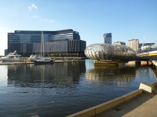
The other end of the Webb Bridge is like a snake shape where there are open shades covering it. The said bridge are only enjoys by pedestrians and cyclists, it links Southbank Promenade at Yarra’s Edge and the Docklands. From Southbank Promenade at Yarra’s Edge or Yarra Esplanade, I got a snapshot of Dockland side where ANZ head office is located and the surrounding docking area nearby.


 Webb Bridge
 Marina YE near at Yarra’s Edge
and ANZ office behind

Southbank Promenade at Yarra’s Edge (or Yarra Esplanade)
 Webb Bridge, Charles Grimes Bridge (at the back of Web Bridge) and
Southbank Promenade at Yarra’s Edge (right side)
 Southbank Promenade at Yarra’s Edge (or Yarra Esplanade)
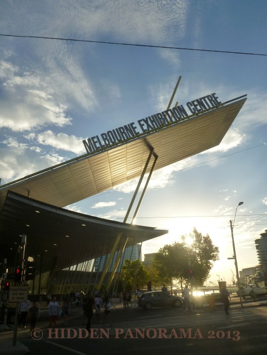
I moved on, looked around and skimmed again the map that I was holding to see what’s next to discover. Since I was walking at the side of Southbank Promenade, I had a view of Dockland. My walk continues and I passed the underground of Charles Grimes Bridge, then SouthWharf where DFO (Direct Factory Outlet) mall is, with some bar and restaurants outside. I walked along South Wharf Promenade until I saw Melbourne Convention and Exhibition Centre. I passed the nearby Seafarer’s Bridge which is another walking bridge like Webb Bridge that will take people in the Docklands or CBD.


Yarra River at Southbank Promenade near at DFO
 Charles Grimes Bridge at Yarra River and the Docklands at the end of it


South Wharf Promenade
 Side Entrance of DFO
 Bar / Restaurant at South Wharf Promenade


 Melbourne Convention and Exhibition Centre
 Seafarers Bridge

 Some photos at South Wharf Promenade
In my walk I did not missed historical Polly Woodside Tall Ship which is located in historical Duke and Orrs docks which was the ships home during its early days in South Wharf. I crossed the busy Spencer Street and I saw Crown Entertainment Complex. The front of the complex is called Yarra Promenade, where a lot of people are passing by, the place is really nice because of its relaxing ambiance, beautiful view of river and line of trees. While walking along the promenade I had a glimpse of Batman Park at the other side of the river.

Polly Woodside Tall Ship
 World Trade Center Wharf, Crowne Plaza, Spencer Street (bridge),
Crown Entertainment Complex and Yarra River from South Wharf Promenade
 Seafarers Bridge and Yarra River
 Melbourne Convention and Exhibition Centre
 Spencer Street bridge
 Melbourne Convention and Exhibition Centre from Spencer Street bridge
 Clarendon Street which connects to Spencer Street
 Spencer Street


 Melbourne Convention and Exhibition Centre
 Batman Park at the other side of Yarra River with Rialto Twin Tower
 Batman Park, Rialto Twin Tower, and Kingsway road bridge
 Crowne Plaze and Spencer Street bridge
 Melbourne Aquarium
 Kingsway road bridge, Rialto Twin Tower and Melbourne Aquarium
 Melbourne CBD skyline with Yarra River at Yarra Promenade
 Spencer Street bridge from Yarra Promenade
I crossed under the Kingsway road, I had a glance of Melbourne Aquarium and Rialto Twin Tower. Next thing I saw after Batman Park is called Enterprize Park where I discovered from the brochure that the park is a site for ‘Scar Project’ where represents the “scar tree”. Based from the information printed, the First people of Australia which called Aboriginal people did took pieces of bark from some trees and called it as “scar tree”. Scare tree is a sign that you entered the land of another community. Learning this information is fascinating, I discovered something from my walk. In the same park, I saw from a far the art called Constellation but I not clear as it should be.


 Some photos around Yarra Promenade

 Eureka Tower
 Mario playing his guitar along Yarra Promenade
I passed another bridge named as Queens Bridge, it is similar to Spencer Street with tram track and both busy with vehicles and trams. I saw historical Sandridge Railway Bridge, an old railway bridge from Flinders Street to Port Melbourne in late 19th century. I never walked anymore in the bridge at that time because I passed it few times. Along the bridge are arts display and I got to know that sculptures are called “The Travellers” which depicts different types of immigrants arrived by train from the pier station. Aside from the sculptures, I saw the list of countries of immigrants of Australia and found my country Philippines on the list.
 Queens Bridge
 Crown Entertainment Complex
 After passing Queensbridge Street, I saw this nearby
(my walk was during Melbourne Food & Wine Festival)
 Queens Bridge and Melbourne CBD
 Sandridge Bridge after passing Queens Bridge
 Sandrdige Bridge from Southbank Promenade
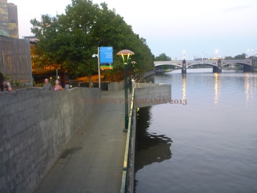
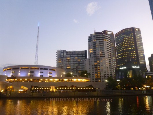
After passing Sandridge Railway Bridge, I continued my walk at Southbank Promenade until I saw Southbank Pedestrian Bridge. Here, I stroll along the bridge itself to be able to take pictures with another angle of the city skyline of Melbourne with Yarra River. The bridge has a bar and restaurant underneath called Ponyfish Island Cafe and from the same bridge I got a couple of photos of Flinders Street Railway Station, Southbank Promenade, Southgate (shopping centre), Hamer Hall and Princess Bridge where St Kilda and Swanston Street end meets.
 Flinders Street Station (with clock) and Melbourne CBD
 Flinders Street Station, Melbourne CBD and Southbank Pedestrian Bridge
 Flinders Street Station from Southbank Promenade
 Southbank Pedestrian Bridge and Ponyfish

 Melbourne CBD skyline with Yarra River
 Princes Bridge


Crossing Southbank Pedestrian Bridge

 Flinders Street Station Clock
 Flinders Walk
 Southbank Promenade
 Eureka Tower from Southbank Pedestrian Bridge
 Southbank Promenade with Southgate Mall
 Lastly, I walked at Flinders Walk where the famous Flinders Street station located. And from this location I was able to capture Eureka Tower near at Southbank Promenade.
 Princes Bridge, Hamer Hall and Southgate Mall in Southbank Promenade


Southbank Promenade and nearby areas captured from Flinders Walk
 Princes Bridge and Hamer Hall
 Hamer Hall (left)
-37.815018144.946008


 from Howard Drive")
 from Howard Drive")


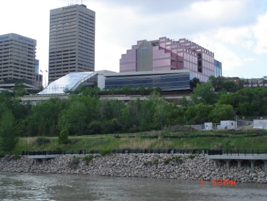
 View At My Window (Post#6) : North Saskatchewan River


 The Cave
 Inside the Museum

 Old Pool


 Entrance
 Friendly Trail

 Capilano Suspension Bridge

 Treetops Adventure
 Cliffhanger Boardwalk
 swamp inside the forest
You must be logged in to post a comment.